
Biking in Chico: Explore Bidwell Park Trails and Scenic Road Routes
(Originally published )
Biking is part of everyday life in Chico. Recognized as a Gold-Level Bicycle Friendly Community, the city makes it easy to explore on two wheels with 11 paved multi-use paths and strong local support from groups like Chico Velo.
Flat paths connect neighborhoods and downtown, while Bidwell Park opens up miles of riding through creek corridors, basalt cliffs, and woodland just minutes away.
Below are a few ways to ride, whether you’re cruising around town or gaining elevation.
As always, please practice Leave No Trace and check trail conditions before heading out, especially during the wetter months.
Leisure & Family-Friendly
Perfect for kids, families, cruisers, and riders looking for breathing room and a relaxed pace.
DOWNTOWN LOOPS
Grab a coffee downtown, cruise the paved paths, and end up creekside while you sip.
Map →
LITTLE CHICO CREEK PATH
A 4 mile out-and-back paved route that winds through scenic green space and quiet residential neighborhoods.
Map →
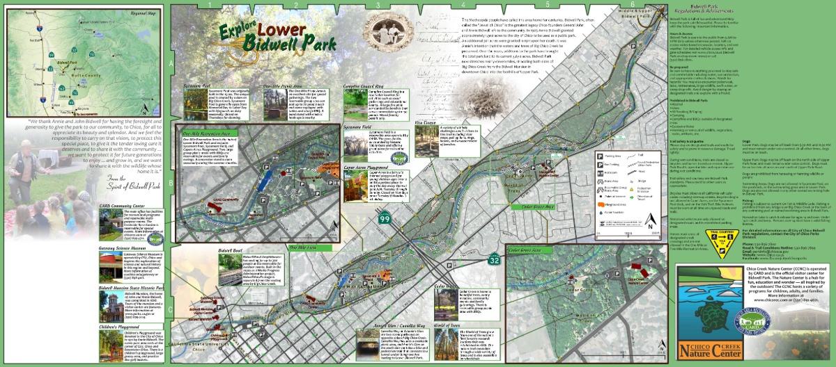
LOWER BIDWELL PARK
Enjoy 1 to 5 mile paved loops beneath a lush canopy of trees. This is a go-to spot for families, beginners, and anyone looking for an easygoing ride.
Map →

Road Cycling Classics
For those who enjoy long miles and taking in some of Chico’s classic farmland scenery.
THE KEEFER ROAD LOOP
This loop takes you over an abandoned railroad bridge, past the Chico Airport, and through wide-open pasturelands with orchard views.
Map →
HONEY RUN LOOP
A moderate elevation ride that features the iconic Honey Run Bridge area and views of the winding Butte Creek canyon.
Map →
CHICO RIVER ROAD LOOP
Offers flat orchard miles with a reward of lush river greenery as you reach the banks of the Sacramento River.
Map →
Mountain Biking & Dirt
Get off the pavement and into the wild! These rides range from dirt paths to the technical volcanic terrain that Chico riders live for.
GUARDIAN AND SOUTH RIM LOOP
Climbs volcanic South Rim before descending the fast and flowy Guardians trail, with a constant view of the Big Chico Creek canyon.
Map →
MIDDLE TRAIL
Winds through the heart of the park with moderate uphill sections, plus several opportunities to bail out onto Lower Trail along the way. Check out this video from our friends at Tails Ales & Trails to see it in action.
Map →
ANNIE BIDWELL TRAIL
A singletrack following the Big Chico Creek through shaded rock gardens. This is more of a beginner-friendly trail, but expect company on weekends as it is shared with hikers.
Map →
BLOODY PIN TRAIL
A direct plummet from the high North Rim. It’s a concentrated dose of the park's raw terrain, forcing riders to navigate kinks and uneven lava shelves as they drop toward the creek.
Map →
Be a Part of a Group Ride
The best way to experience Chico’s "Gold-Level" status is to ride alongside the locals who built the culture.
CHICO VELO EVENTS
Join rides like the Wildflower Century, a beloved Chico tradition that’s been bringing cyclists together for over 40 years, or try their summer gravel outing, Gravel Grind, exploring backroads near Butte Meadows with route options for a range of experience levels.
WEEKLY GROUP RIDES
Looking for a mid-week spin? Connect with the North Rim Adventure Sports crew for information on their regular community events.
For those who want to roam beyond the pavement, ask about their Gravel Club and hit the backroads. Find a Ride →

EXPLORE BUTTE COUNTY
Coming Soon: Chico Bike Park
Currently under development on Humboldt Road, the Chico Bike Park is slated for completion by Summer of 2026. This six-acre facility is a collaboration between Chico Velo and CARD, designed to be a premier destination for cyclists.
- Built for All Skill Levels: From kids learning jumps to seasoned mountain bikers tackling special features
- Skill Building: Jumps, wooden features, and off-road courses
- Inclusive Design: Thoughtfully designed for riders of all ages and abilities
- Community Focused: A place to ride, connect, and build lasting memories
Before You Go
A little prep goes a long way. Here’s what to know before you roll out.
BIKE RENTALS AND SHOPS
You’ll find secure, well-lit bike parking at most businesses, but bring a bike lock. Even on short stops, it’s a must.
Traveling without your own ride? Greenline Cycles has rentals and can point you toward routes that match current conditions.
MAPS AND ROUTES
Don't get lost in the park! Download the official city maps of Lower & Upper Park or browse the deep archive of local routes maintained by our partners.
WEATHER AND CONDITIONS
Chico summers can get hot quickly, and winter rains can make some trails muddy or temporarily closed.
Plan rides earlier in the day during warmer months and always check trail and weather conditions before heading out.
Many paths, especially in Upper Park, are exposed with limited water access. Carry more water than you think you’ll need, and plan accordingly!
TRAIL ETIQUETTE
Trails are shared by bikers, hikers, and runners. Yield to pedestrians, yield uphill to climbing riders, communicate when passing, and help keep the experience positive for everyone.
Chico Velo’s bike safety tips are a great resource for understanding rules of the road.

Relax & Refuel
Once the ride’s done, the day doesn’t have to be!
After tackling volcanic ridges, or even squeezing in a short loop around One Mile, Chico’s patios and gathering spots are the perfect place to wind down.
See you out there. Tag your photos with #TravelChico to share your adventure!


Recent Stories
- Romantic Things to Do in Chico, California Jun 5, 2026
- A Guide to Chico's Dining Scene Jun 5, 2026
- Summer in Chico: Things to Do & Your Bucket List Jun 5, 2026


